Use of the AIEM permafrost module output to assess the permafrost changes in the 21st century
Project Personel
Main Contact: Dr. Vladimir E. Romanovsky
Scientific Personel: Vladimir Romanovsky, Dimtry Nicolsky, Sergey Marchenko, Frank Urban, Reginald Muskett, Santosh Panda
Collaborators:
Partner Organizations: USGS and Alaska Native Tribal Health Consortium (ANTHC)
Project Summary
Project datasets available at USGS
https://cida.usgs.gov/thredds/catalog/AIEM_permafrost/catalog.html
Peer-reviewed paper available at JGR Earth Surface
http://onlinelibrary.wiley.com/doi/10.1002/2016JF003852/abstract
Short description: The permafrost module of the Alaska Integrated Ecosystem Model (AIEM) was used to establish several high spatial resolution (1km x 1km) and very high resolution (30m x 30m) scenarios of changes in permafrost characteristics in the Alaskan Arctic (Figure 1). These changes are in response to projected climate change and northern infrastructure development. Impact of these changes on permafrost on northern Alaskan ecosystems and infrastructure were assessed and regional maps of the possible impacts were developed.

Figure 1. The location of permafrost observational sites on the North Slope operated by USGS and by the Geophysical Institute of UAF. The red line shows the boundary of the proposed modeling domain.
Key Findings:
High-resolution ecosystem maps of the Alaska North Slope were found to provide a convenient upscaling mechanism to parameterize ground soil properties across the study area over the validation period of 1990 to 2014 in accordance with ALT observations at CALM sites. Computations of the MAGT, ALT, and talik thickness projections into the future for climate scenarios RCP 4.5 and 8.5 illustrate a drastic difference in the future near-surface ground temperature regimes in 2050s and 2090s (Figure 2).
RCP 4.5:
Under this scenario our current model predicts only a modest increase in the near-surface permafrost temperatures and a limited degradation of the near-surface permafrost in the Alaska North Slope region. We suggest in order to keep permafrost from substantial thawing, the RCP 4.5 scenario most likely needs to be a target for the greenhouse gas emissions.
RCP 8.5:
We found ALT that was up to 0.5 m on average in 2000, increases by a factor of 2 by 2050. From 2050 to 2100 ALT continues to increase and widespread taliks starts to form in the Alaska North Slope region. Taliks will have serious implications for ecosystems, human activities (infrastructure and subsistence lifestyle), and potential feedbacks to climate change.

Figure 2. Maps of the modeled ALT and talik distributions for across the North Slope of Alaska for RCP 4.5 and 8.5 in the period as shown. (Ref. Nicolsky, D.J., Romanovsky, V.E., Panda, S.K., Marchenko, S.S., Muskett, R.R. (2017), Applicability of the ecosystem type approach to model permafrost and ground temperature dynamics across the Alaska North Slope. J. Geophys. Res. Earth Surface, 122, 50–75, doi:10.1002/2016JF003852)
Orginal Project Prospectus, Methods and Techniques and Expected Outcomes
B1. JUSTIFICATION Permafrost temperatures are rising in most regions of the planet, threatening widespread permafrost thaw and degradation. Where thawing has occurred dramatic changes in ecosystems and existing infrastructure are evident. Negative consequences are already pronounced and will continue as ground ice continues to melt. These observed changes stress the necessity to develop a regional approach in predicting changes in permafrost for timely assessment of potential consequences of permafrost degradation to ecosystems and infrastructure. The regional approach should be complemented by a capability to project changes and impacts on the local scale at very high spatial resolution. The adaptation to future changes in permafrost is inherently a local and regional scale issue, and limited by the measure of confidence in the projected changes at these scales. It is at regional and local scales that credible information of probable climate change and the associated changes in the environment is most needed. For permafrost in particular, site-specific information is necessary for planning with respect to infrastructure such as roads, airfields, settlements, and commercial and subsistence activities (e.g., resource extraction, hunting, and food storage).
The research proposed here seeks to further bridge the gaps between climate change modeling, permafrost science, and stakeholder needs at the regional scale within northern Alaska. In this project we will develop a new approach to address specific problems that changing climate and degrading permafrost impose on northern ecosystems and infrastructure. More specifically, a suite of various downscaled climate scenarios of external (greenhouse) forcing will be used to model changes in permafrost. These regional-specific scenarios will enable us to pursue central permafrost questions such as the precise location of different zones of permafrost, accurate estimates of rates of permafrost degradation and accurate estimates of the active layer depth and seasonality. This approach combines results of climate modeling with spatially oriented permafrost modeling at scales of societal interest in a manner that will meet the decision-support and information-assessment needs of planners and stakeholders.
B2. BACKGROUND Permafrost is a central element of the cryospheric system. Its role in the climate system and more generally in the Earth System has become increasingly recognized by the public as well as in the scientific literature, especially in the most recent years (Nelson et al., 2001; ACIA, 2004; Hinzman et al., 2005; Smith et al., 2005; IPCC, 2007b; Schuur et al., 2008; Gooseff et al., 2009; Rowland et al., 2010). Changes in permafrost affect not only regional and possibly global climates, but also have a pronounced impact on local and regional ecosystems (Martin et al., 2009) and infrastructure (Nelson et al., 2001). Despite our current general understanding of how permafrost is changing and may change in the future, due to changes in climate, it is still very poorly understood how these changes will affect ecosystems and infrastructure on local and regional scales. The major hurdle in addressing this problem lies in our limited knowledge of local processes and consequences due to insufficient spatial and temporal resolution of models and projections of changing climate and resulting changes in other environmental characteristics, including permafrost.
Permafrost characteristics vary widely across the Arctic and within Alaska (Brown et al., 1997; Jorgenson et al., 2008). Northern and especially north-west Alaskan communities are very susceptible to permafrost degradation because of generally high ice content in permafrost and because stable bedrock is often not near the surface. For the same reason, coastal erosion hazards along the ocean shore and riverbanks are very common in Alaska and affect many Alaskan communities, with more than 85% of Alaska Native villages negatively impacted to some degree by erosion and flooding (USGAO, 2003). Of these 184 villages, 17% have been identified as facing imminent threats to life and property, while nearly half of them have already decided to relocate (USGAO, 2009). Roads and other linear infrastructure usually encounter permafrost-affected ground with ice-rich fine-grained material and may have severe permafrost-related problems.
Recent assessments of permafrost demonstrate ongoing warming over large areas (ACIA, 2004; Romanovsky et al., 2007; Brown and Romanovsky, 2008; Romanovsky et al., 2010a, 2010b; Smith et al., 2010), and local evidence of permafrost degradation is apparent in parts of Alaska, Russia and Canada. As a result of our prior research, a predictive permafrost model of moderate spatial resolution was developed for Alaska. The Alaskan 2x2 km resolution model predicts substantial permafrost degradation in most of the Alaska. By the end of the 21st Century permafrost will be relatively stable only in the Brooks Range and the North Slope. ACIA (2004) used coarse resolution global climate models to infer the likelihood of substantial reductions in permafrost area by the end of the present century. While the projected reductions in permafrost extent ranged from 10% to as much as 40%, these projections are subject to three major caveats: (1) they are driven by output from coarse-resolution (~300 km) GCMs of late-1990s vintage, (2) they do not capture fully the time lags between surface warming and the thaw of permafrost in areas of thick permafrost, and (3) the climate models suffer from systematic biases (some poorly known) partly caused by an incomplete treatment of snow and subsoil processes (Nicolsky et al., 2007a; Lawrence et al., 2008). Nevertheless, even smaller changes in permafrost extent have serious implications for ecosystems, human activities (infrastructure and subsistence lifestyle) and feedbacks within the climate system (especially with respect to carbon and water fluxes). To address these problems a new technology needs to be developed that will include the summarizing existing observational data, the use of remote sensing data and GIS technology, and include retrospective and predictive modeling of permafrost dynamics and possible consequences of its degradation. The technology developed in this study will be relevant and applicable to the many Alaskan and other Circum-Arctic locations.
B3. OBJECTIVES
In the light of limitations of prior permafrost assessments the present proposal has been designed with the following primary objectives:
1. Assemble necessary high resolution vegetation and soil properties data for the entire Alaskan North Slope region;
2. Assemble necessary high resolution climate forcing data for both retrospective and predictive modeling of permafrost dynamics;
3. Use of state-of-the-art permafrost models to determine the response of permafrost to these climate change scenarios at high spatial resolution;
4. Use available permafrost temperature data for model calibration and quality assessment of the modeling results;
5. Design and implement several numerical experiments to study the effect of different type of surface disturbances on permafrost temporal evolution.
The project has several primary components that will be necessary in order to achieve the objectives listed above:
1. A consolidation (for model applications) of existing observations on permafrost and active layer dynamics at a series of USGS and UAF climate and permafrost monitoring sites within the North Slope of Alaska and in the vicinity of the community of Selawik, Alaska.
2. Development of high-resolution retrospective (1950-2010) and several prognostic (2010-2050) scenarios of climate change over northern Alaska and high resolution maps of the environmental parameters (snow depth and density, mineral and organic soil thickness and physical properties, surface vegetation characteristics etc) that are essential for modeling permafrost temperature and its distribution, and for determining the active layer characteristics.
3. A quantitative assessment of how permafrost responds in natural conditions to the prescribed climate changes using a state-of-the-art permafrost model, which will permit mapping of past and present permafrost conditions and future permafrost dynamics within the North Slope of Alaska and in the vicinity of the community of Selawik, Alaska.
4. A quantitative and spatially explicit assessment of how various surface disturbances will affect permafrost and active layer characteristics under different climate scenarios, which will permit mapping of permafrost degradation and surface subsidence within the North Slope of Alaska and in the vicinity of the community of Selawik, Alaska as a result of these disturbances.
C1. ULTRA HIGH-RESOLUTION MODELING
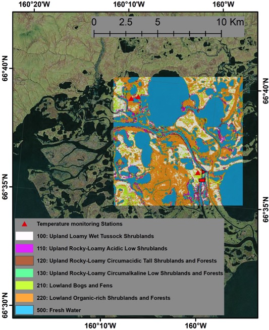
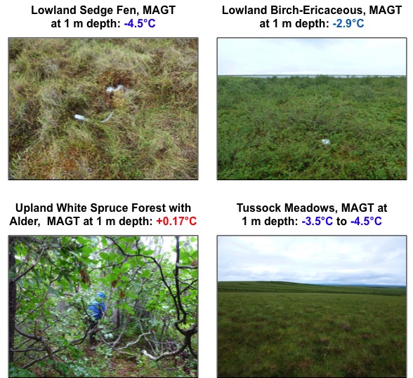
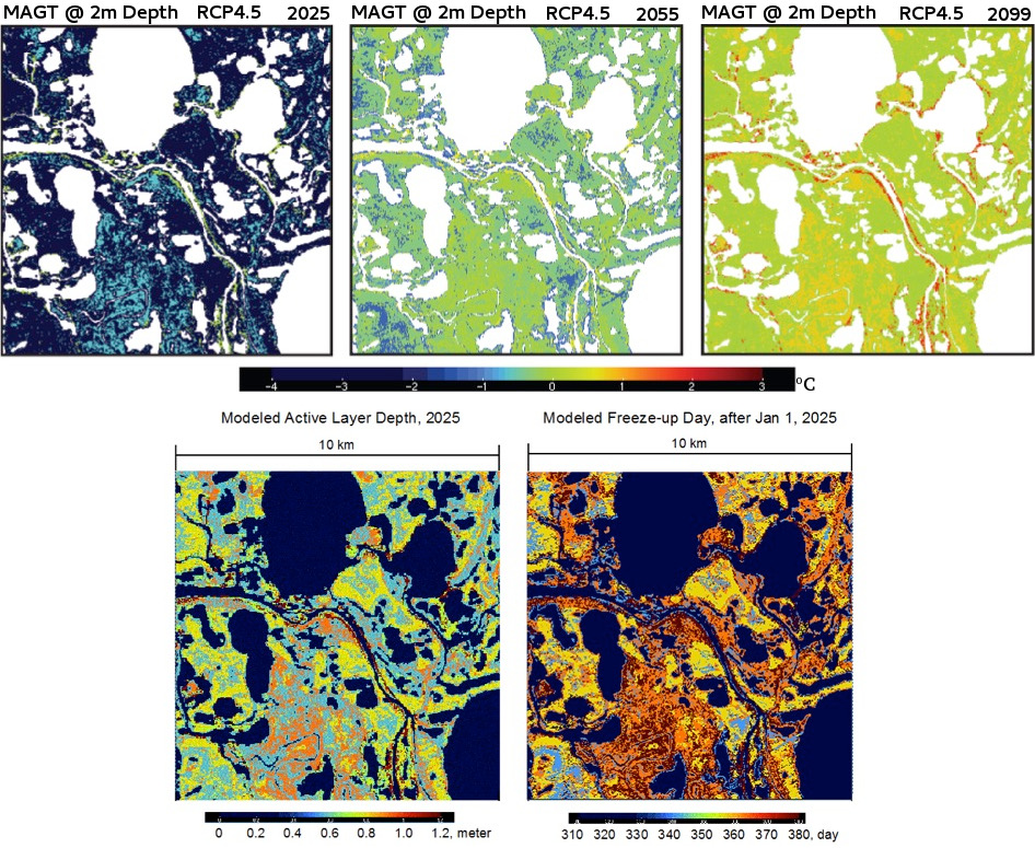
The focus region for ultra-high-resolution permafrost-ecosystem-climate modelling is a 10 kilometer square area in the Selawik National Wildlife Refuge of western Alaska, Figure 3. Our efforts builds upon research conducted by Shur and Jorgenson (2007) classification scheme for permafrost stability based on ecotypes and the permafrost monitoring network sites established by Cable et al. (2016). The ecotype map is based on NASA-USGS Landsat Enhanced Thematic Mapper Plus sensor with in-situ observations at 30m ground resolution. Inputs to our modeling include hourly air and ground and active layer temperatures, water content, soil texture and thermal properties, Figure 4. After initialization and spin-up using historical climate observations employ climate parameters from RCP 4.5 and 8.5 for future projections of mean annual ground temperature (MAGT) at 2m depth, active layer depth and freeze-up day up to years 2025, 2050 and 2099, Figure 5.

Figure 3. Selawik National Wildlife Refuge (SNWR), 10-by-10 km modeling area, ecotypes and permafrost monitoring stations.

Figure 4. Ecotypes in the modeling area of the SNWR.

Figure 5. Snapshots of modeling results of MAGT at 2m depth for RCP4.5 through years 2025, 2055 and 2099 (top) and active layer depth and freeze-up day for RCP4.5 through year 2025 (bottom).
References:
Cable, W.L., Romanovsky, V.E., Jorgenson, M.T. (2016), Scaling up permafrost thermal measurements in western Alaska using an ecotype approach. The Cryosphere, 10, 2517-2532. DOI: 10.5194/tc-10-2517-2016.
Shur, Y., Jorgenson, M.T. (2007), Patterns of permafrost formation and degradation in relation to climate and ecosystems. Permafrost and Periglacial Processes, 19, 7-19. DOI: 10.1002/ppp.582.


