Establishing a Permafrost Observatory at the Gakona HAARP Site
Project Personel
Main Contact: William Cable
Scientific Personel: V. E. Romanovsky, Yu. Shur (Departament of Civil and Environmental Engineering UAF, Alaska), K. Yoshikawa (Water and Environmental Research Center, UAF, Alaska), G. S. Tipenko
Collaborators:
Partner Organizations:
Project Summary

The Gakona HAARP Observatory is located in a large intermountain depression in the Copper River Basin, which exhibits wide permafrost extent. This area is the southernmost location in Alaska with practically continuous permafrost. Ice-rich glaciolacustrine deposits fill this depression. The glaciolacustrine deposits of the Late Pleistocene are some of the most ice-rich deposits developed during the last glaciation. Their properties create great challenges to engineers because they are both highly frost-susceptible in the active layer and highly thaw-susceptible in the permafrost layer. Investigations by the US Army Corps of Engineers (1954) described varved clay in the area to a depth of 30 m as ice-rich with stratified ice lenses up to 5 cm thick, and with the occasional occurrence of buried massive ice as thick as 4 m below the clay layer.
Establishing of the HAARP Permafrost Observatory will make a valuable contribution to the permafrost observation system of the University of Alaska Fairbanks (UAF) Geophysical Institute that was established by Prof. T. E. Osterkamp in the 1970s and 1980s and has been maintained and expanded by the Permafrost Lab of the Geophysical Institute. The location of the HAARP Permafrost observatory at the southern limits of Alaskan permafrost will create an important counterpart to the recently established Barrow Permafrost Observatory.
Permafrost in the area is widespread, in spite of its location at the southern boundary of the discontinuous permafrost zone. The average annual temperature of the permafrost has been steadily increasing in Alaska in general and in the southern part of Alaskan in particular during the last 20 years at undisturbed locations. Existing data show that permafrost in this area is extremely sensitive to changes in climate and other factors (changes in snow depth and density, soil moisture and surface hydrology, vegetation changes, adjacent landscapes stability, etc.), which could affect permafrost temperature and stability. Permafrost here is also very vulnerable to surface disturbances, both natural and human-made.
The Copper River Basin is well known for geotechnical problems resulting from settling of thawing permafrost and heaving of highly frost-susceptible soil in the active layer. Significant surface disturbances were made within the HAARP site. Natural surfaces that protect permafrost through the insulating effect of the thick organic mat (live and dead moss and peat) were replaced with the artificial surface of the gravel pad. Experience from the past shows that gravel pads in Interior Alaska, even when regular snow removal or compaction is conducted (e.g. gravel parking lots) will eventually lead to thawing of the underlying permafrost. The use of a passive refrigeration system to stabilize antenna towers could increase stability of permafrost and protect it from thawing for some period of time. However, it is unclear for how long this measure will keep permafrost within the antenna field in stable condition. To answer this question a comprehensive permafrost monitoring program, including continuous temperature measurements, periodical geophysical observations, and sophisticated numerical modeling, should be implemented. It should be also stressed that even if the antenna field itself will be protected by the installed refrigerating system, the permafrost degradation in surrounding area will dramatically change environmental conditions (including first of all the surface and subsurface hydrology), which will eventually create significant problems for normal functioning of the HAARP project.
During the Summer 2004 we completed the initial survey campaign. Obtained data supported our preliminary conclusion that the partial thaw of permafrost from top down tightly relates to distinguish surface micro topographical features. These features are elongated depressions (0.5 to 1.5 m deep) with no trees and no moss on the ground surface. The depth of the permafrost table within these depressions are different for different locations and vary between 2 and 8 meters according to survey by Duane Miller & Associates and to our temperature measurements in several boreholes. The areas with lowered permafrost surface can be detected from the remote sensing image.
 |
 |
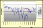
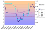
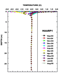
Several boreholes within the gravel pad and in natural conditions were equipped with thermistor strings and loggers to automatically monitor temperature in these boreholes. One such borehole locates near northeast corner of the antenna field in relatively undisturbed conditions. The depth of the borehole is 28 meters. Temperature sensors are spaced equally every 1 m starting with 4 m depth. Additionally, soil temperature is measured by sensors installed directly in the ground at depth 1.4 m and approximately every 10 cm within the upper 1 m. The automatic readings of temperature are taken every 5 min, averaged hourly and stored in the data logger memory.
 |
 |
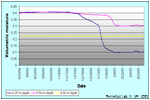
Air temperature and soil liquid water content are also measured hourly at this location. One more borehole in natural conditions (5 meters deep) within the open area of an elongated depression (62° 24.121´ N, 145° 09.393´ W) was equipped with a thermistor string and a mini-logger. The rest of the boreholes are within the gravel pad of the antenna field. These boreholes were drilled as a part of a Duane Miller & Associates project in the Summer 2003 and temperature in these boreholes was measured on July 17 – 18, 2003 and on September 12 – 13, 2003. Our installations in these boreholes were made in agreement with Duane Miller & Associates. Temperature readings in these boreholes will be made automatically every hour and data will be stored in data loggers memory. Data from the data loggers will be downloaded periodically during our visits to the HAARP site.
The readings at all installed boreholes started in early July and in the late August. An example of collected so far data is shown in Figures to the right.
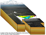 |
As part of our initial survey, we applied geophysical methods (DC Resistivity and Ground Penetrating Radar) to investigate permafrost distribution in vertical and horizontal directions within the HAARP antenna field and in adjacent area. The most interesting and certain results were obtained from DC Resistivity survey (Syscal Pro R1 switch 72 channel resistivity system). Two profiles were surveyed. One, along the east side of the antenna field, started in the northeast corner and went through the entire field and into the spruce forest. The second profile was traced west-east along the row # 8 of the antenna field.
The interpretation of the DC Resistivity survey results show that permafrost in the forest is stable and contain a limited amount of unfrozen water (resistivity is 600 ohm-m and higher, up to 1800 ohm-m). The lower boundary of permafrost here locates at the depth 50 to 60 meters. Permafrost in the northern part of the north-south transect is also stable, but with significantly larger amount of unfrozen water (resistivity between 100 and 1000 ohm-m). Permafrost thickness here is close to 40 meters. According to this data, a very interesting and distinct feature locates under the central part of the north-south transect.
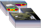 |
The sub-surface resistivity within this area is very low (10 to 30 ohm-m), which indicates the possibility that ground is not frozen here (talik) or contains very significan amount of unfrozen water ("ice-bearing" permafrost or a lense of clay). The lateral extent of this feature is only 10 meters at the surface increasing with depth to several tens of meters. Penetrating Radar (GSSI Sir-2000 system with 200 MHz antenna) survey also shows similar feature at the same location. Further investigations are needed to determine if this feature is indeed a talik, or it is permafrost with very high unfrozen water content.
East-west transect also shows a zone with low electrical resistivity in the central part of the transect (the location that is very close to the low resistivity zone on the north-south transect). However, the resistivity values higher than 100 ohm-m indicate that the material is still probably frozen. East-west transect also shows that permafrost table within the gravel pad locates at the depth of 2 to 6 meters that is in a very good agreement with measured ground temperature data. The lower boundary of permafrost locates here probably at the depth 25 to 28 meters.


