Recent and future permafrost variability, retreat and degradation in Greenland and Alaska: An integrated approach
Project Personel
Main Contact:
Scientific Personel: J. H. Christensen, M. Stendel (Danish Meteorological Institute), V. Romanovsky, J. Walsh (University of Alaska Fairbanks), K. H. Svendsen (Asiaq), Thomas Ingeman Nielsen, N. Foged (Byg-DTU)
Collaborators: Arctic Region Supercomputing Center Greenland Survey ASIAQ Danish Meteorologic Institute Technical University of Danmark
Partner Organizations:
Project Summary
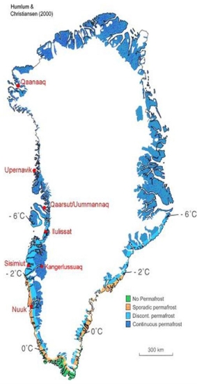
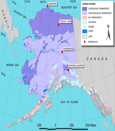
In spite of its role in the geological, ecological, engineering, and climate change sciences, modeling of permafrost has remained the domain of individuals and small groups of scientists and hence little direct interaction between the permafrost and climate modeling community has taken place. The research proposed here seeks to bridge this gap at the local to regional scale for two quite different geographical regions; western Greenland and Alaska. More specifically, climate modeling will be performed at an unprecedented spatial scale that allows us to address central permafrost issues such as the accurate delineation of different zones of permafrost, active layer depth and seasonality, thereby combining climate modeling with spatially oriented approaches to permafrost modeling at scales of societal interest. The project will incorporate existing near-surface weather, climate and permafrost observations supplemented with new targeted measurements at locations where climate change is presently taking place, e.g. in the discontinuous permafrost zone. The following are the project’s main objectives:
The provision of transient regional climate change scenarios through 2050 at unprecedented spatial resolution for two very distinct areas of permafrost: western Greenland (a coastal/maritime permafrost regime) and northern Alaska (a continental interior permafrost regime) with a thoroughly validated regional climate model for the Arctic
Establishment of a series of permafrost and climate monitoring sites representative of the range of permafrost types encountered near the permafrost margin of the two regions
Implementation of a state-of-the art permafrost model to be calibrated against field measurements and to be driven by the output of the regional climate model
A quantitative assessment of how permafrost responds to these climate change scenarios using state-of-the-art permafrost models, which will permit mapping of the permafrost conditions for the present and future
An evaluation of the implications of the results in the context of planning as well as mitigation and adaptation to climate change in Greenland and Alaska
A demonstration of the added value of this high-resolution modeling approach for Greenland and Alaska, given the significant differences in geography, climatology and infrastructure.
Of these objectives, the first four represent the project’s main scientific thrusts, while the latter two represent broader impacts and outreach also to the non-science community.
- Regional climate change scenarios at high resolution
- Series of permafrost and climate monitoring sites
- Use permafrost models to determine the response to climate variability and change
- Implications in the context of planning, mitigation and adaptation
- Demonstration of the added value of high-resolution modeling
 |
 |
- Project tasks at each site
- High-resolution simulations of climate over the permafrost margins of Greenland and Alaska, for the present and reaching into the future (2050)
- Establish a series of climate and permafrost monitoring sites in Greenland and Alaska representative of the range of permafrost types encountered near the permafrost margin
- Implementation of a state-of-the art permafrost model to be calibrated against field measurements and to be driven by the output of the regional climate model
- Mapping of permafrost conditions for the present and projections of the variability of permafrost
- Documentation of likely changes through 2050, and construction of "risk maps" for the respective regions, together with recommendations concerning infrastructure and engineering
Installation of thermistors and snow sensors in Greenland. Sampling permafrost cores in Illulisat. Upgrading thermistors in Deadhorse Alaska.
An example of modeling permafrost degradation in Fairbanks Alaska
Introduction to GIPL 2.1
GIPL2.1 has a multi processor numerical nonlinear heat equation solver with all the necessary input and output options. Its predecessor is also discussed in other pages in our webpage. GIPL2.0 is working with GIS based input variables for spatially distributed soil, snow and vegetation properties. For the simplified simulations shown below we used bedrock properties that are identical for each simulated node point. Snow densities were assumed constant and snow depth and air temperature was taken from the regional climate model HIRHAM 4.0. For initial conditions we used a soil surface temperature equal to the air temperature. The bottom boundary condition is a heat gradient of 2 degrees per 100 meters starting at 1000m with 20 degrees Celsius. At 20m we applied the annual average air temperature over the first 10 years of input data. Between these data points we applied a linear interpolation. To make the initial condition better we used a spinup period of 100 years with monthly average air temperatures for the first 10 years of data.
Results from GIPL2.1 for permafrost temperatures at 0.5 m, 2m, 5m, and 10m depht. The years start with a spinup of 100 years and then continue with 125 years of simulated air temperatures (HIRHAM 4.0) starting in the year 1950.
Data from the Greenland sites associated with this project can be found here:


